In March 2009, Virtual Alabama was used to track a shooting spree in Geneva County that killed 10 people and also resulted in the perpetrator's death. Investigators within the governor's crisis command center used Virtual Alabama to follow the shootings as they occurred, including elements such as the time it took the shooter to travel from one location to another, the distance covered and the fatalities' identities. With that information, the investigators could draw comparisons as they investigated the crime. Simultaneously they shared that information with the mobile command center that deployed to the county.
These are just two examples of Virtual Alabama's utility. The system improves disaster response through better data sharing and allows city, county and state agencies to collaborate in innovative ways. Before Virtual Alabama, it took the state days, if not weeks, to prepare disaster declarations -- and they weren't always the most accurate. With Virtual Alabama, the state can look at irrefutable evidence of damage and quickly determine its extent.
Inspired by Katrina
The impetus for the application came after rains from 2005's Hurricane Katrina drenched Alabama. Having seen more than 450 tornadoes strike the state during his time in office, Gov. Bob Riley turned to state Homeland Security Director Jim Walker with two simple but important questions: How was he going to assess the damage and apply for federal aid if he didn't know what the communities looked like before the storm? And shouldn't all that imagery be stored in one place?Walker's answer to the governor's challenge was to build Virtual Alabama using locally owned imagery on a secure, permission-based Google Enterprise platform. Getting started was relatively inexpensive: The state spent less than $150,000 for the software licenses and hardware.
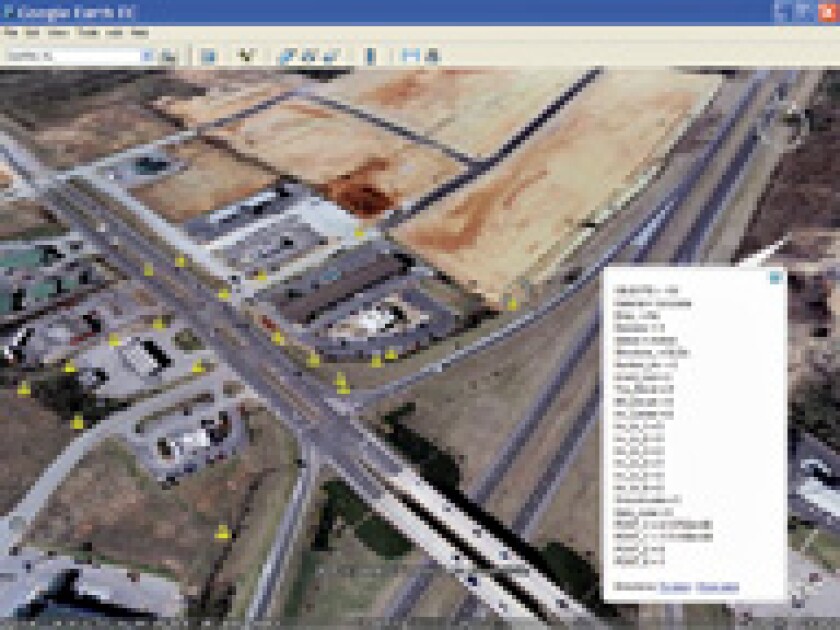
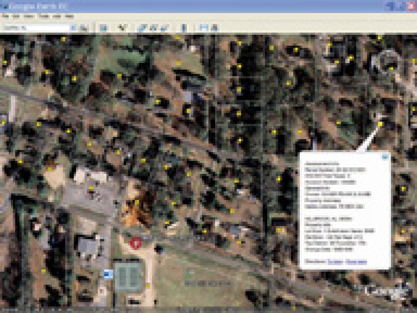
The system contains location data for sewer, water and power lines; radio towers; police cruisers; fire hydrants; building schematics; sex offenders' addresses; approved landing zones for medical helicopters; inventories of hospitals and cached medical supplies, such as respirators; evacuation routes; shelters; land-ownership records; and assessed property values.
Some of the data stitched into Virtual Alabama is sensitive, like floor plans for public buildings. For that reason, even though the data is potentially available to anyone at any level of government, access control is retained by the custodial owner of that information and protected by that agency's security protocols. As needed, first responders -- such as SWAT teams, bomb squads and firefighters -- can request access to the information. "If the custodial owner stays in full control of the data, then [he or she has] no fear of it being breached because it's inside their firewall," said Chris Johnson, Virtual Alabama program manager and vice president of geospatial technologies for the U.S. Space and Rocket Center in Huntsville, Ala.
Virtual Alabama's platform provides access to the same technology that's behind Google Earth, except it's accessible only to government employees with the proper permissions. "We do this on our own servers behind our firewalls, and we serve it to whoever we need to serve it to, and it has no interaction ... with [Google's] globe," Johnson said.
If a situation changes quickly, then access can widen or constrict depending on the circumstances. "If at 3:00 in the morning, the school administrator needs to widen that loop to include the sheriff, police chief, the bomb squad and whomever else, then she has full control through her IT staff to do that," Johnson said. Once permission is granted, the
connection is established in real time and data is streamed to partners, but not necessarily stored by them.

Use in a Disaster
Virtual Alabama has given officials unique insights on a variety of fronts, such as who's likely to evacuate during a disaster and how to help them. For example, the state found that low-income residents are less likely to leave their homes as a disaster approaches. By using socioeconomic data plotted on Virtual Alabama, the state's Department of Children's Affairs can predict who's likely to evacuate and develop strategies to remove the holdouts from harm's way.Another reason people may not evacuate during an emergency is concern for their animals' welfare. Recognizing this, the state's commissioner of agriculture, Ron Sparks, made a map of pet-friendly hotels and their costs. The idea is that citizens who have access to this data will be willing to get out of the way of a natural disaster knowing their animals also will be safe.
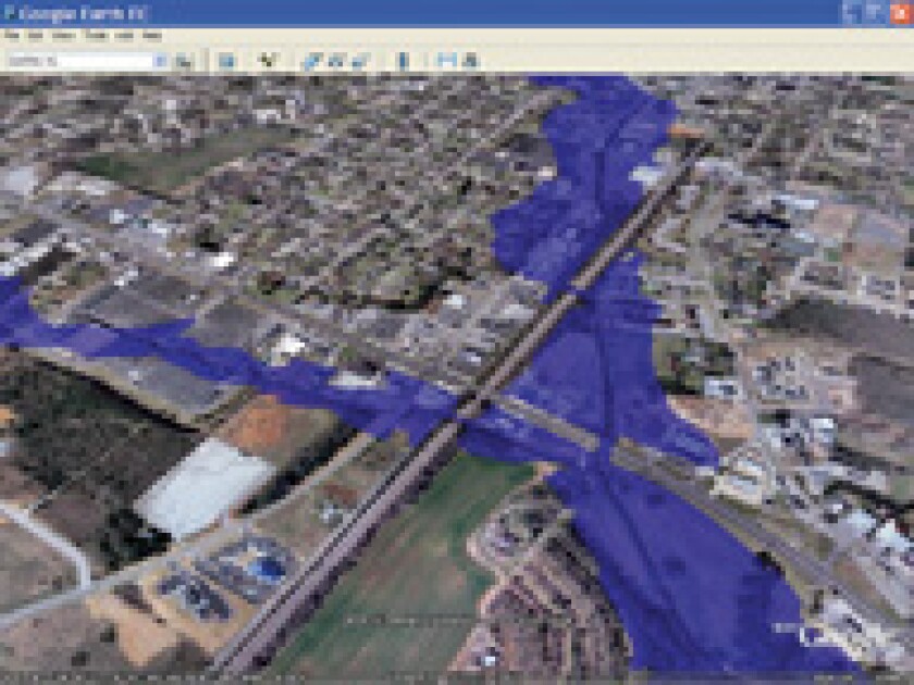
The North Shelby County Fire Department uses the system for basic functions, like hydrant identification and making map books, but it's also useful in assessing tornado damage. "Sometimes you may think you're seeing the picture, but our eyesight is limited. We're blocked by trees, we're blocked by buildings, we can't see what's on the other side of stuff. The system can go and just look," North Shelby County Fire Chief Michael O'Connor said.
"There is just a myriad of uses that is only limited by the individual using it," he said. "It's a wonderful process, and it's going to be part of our new incident command vehicle we're getting shortly."
A major initiative Walker is working on is getting the state's 1,500 schools to import their data into Virtual Alabama. Currently schools can access the system, but they must capture data images they need for inclusion as part of their disaster plans. Feedback about how schools have utilized the program so far has been very positive, according to Sue Adams, director of prevention and support services for the Alabama Department of Education.
A pilot with two schools was to be completed in May. Walker planned to present the pilot's results to school superintendents at their annual meeting in June, and the full implementation of Virtual Alabama in the state's schools will be completed within 18 months.
Distributed Security
Maintaining proper control while sharing information across jurisdictions and between levels has been a perennial challenge for governments. "In the past, if I shared my data with you it meant I had to give it to you," Johnson said. "And I had to trust that you weren't going to share it with anybody else or redistribute or use it in a way that I did not intend. Visualization has blown all of that away because now we're no longer data sharing."With all the data housed within Virtual Alabama -- whether it's land-ownership records owned by a revenue commissioner or sensitive data owned by an environmental agency -- they're all just connections, she explained.
This means it would be difficult for someone to get a complete picture of Virtual Alabama if he or she breached the system. "If we have a breach in our system, it's not a single point of failure," Johnson said. "So you've breached into Virtual Alabama, but you're only seeing the benign layers. We have hundreds of systems that would have to be breached to have an aggregate of the whole."
The security and partitioning of Virtual Alabama is robust enough that even the FBI and Secret Service agents who are operating in Alabama can use the system securely. They use all the system's assets inside their security protocols; but other agencies don't necessarily have access to it, she said.
One key to the system's rapid and wide adoption is that its vector data cannot be stored, exported or removed from the globe. A user can take a screen capture of the data, but the native data cannot be extracted. "However, you can put links in there to the people that hold the native data and their contact information so you can connect to them directly and say, 'Hey, may I have this data for this specific purpose?' For the discovery of data it's been phenomenal," Johnson said.
With Virtual Alabama, the state is trying to increase information sharing. "I'm giving you a feed of information that I think is useful to you. And you think is useful to you, and if I have a change in my situation, as the custodial owner of that data and I need to either send you more data or send you less data or send you no data, then that's in my control," Johnson explained.
The state is working to establish standard operating procedures for the emergency sharing of data housed in Virtual Alabama. The list of people who have access to a particular piece of information changes depending on an alert's level. The IT personnel know who should have access to what data, she said.
For example, after a tornado strikes, the state's Civil Air Patrol photographs the debris trail. The state has a protocol in place so the air patrol knows exactly where to load the data once it lands. "That can change so that if a tornado skips through five counties but it misses two in the middle, you know who needs to have access to that data," Johnson said.