Cities, states and counties treat their data as if it were an alien relic. They know there’s something powerful inside, but they don’t know how to get it out. And rather than mastering this alien technology themselves, they depend on the help of others. Countless apps have been created by outsourcing the data problem to the public, so while it’s a productive approach, it’s also the chaotic silver-medal tact of someone who has given up on controlling his or her own destiny.
Government can do better.
Luis Borrero, founder of a startup that created the data visualization platform DriveDecisions and Chair of Land Use and Transportation at the Seattle Planning Commission, wants governments to take their data into their own hands. In November, former Seattle Mayor Mike McGinn joined the company as public-sector advocate. McGinn said he was so impressed by what the platform can do that he lamented not knowing about it when he was in office.
The primary approach to open data is to publish data and just see what people can do with it, McGinn said. And while that tact has been successful in Seattle and elsewhere, he said, DriveDecisions enables leaders a unique, centralized overview of open data not offered by other tools.
In Seattle, DriveDecisions aggregates 15 live data feeds from portals across the city, county and state -- like building permits, crime and social metrics -- to display a three-dimensional map that can be adjusted to filter, search and cross-reference information. Through the software’s Web-based interface, users can find quick answers to questions, all made clear through visual context, similar to how some offices now use GIS to make decisions.
Unlike most GIS applications, however, Drive doesn’t require training and appears more like a game or consumer app than a software developer’s programming interface.
“I think that we’ve all been looking for ways that there would be useful applications for the public and I know that there have been a number of them, but it’s a little opaque to your average user,” McGinn said. “Someone has to be the translator and that’s what Drive is doing. This puts everything together in a way that didn’t currently exist in government, so it will be good for planning within departments or more centralized planning for the city.”
Data can and should change everyone’s approach to project management in government, Borrero said. Through his time with the Seattle Planning Commission, Borrero has noticed that government workers are constantly being asked to form opinions and make decisions, but there’s rarely enough time or information to clearly understand each topic.
“The [Seattle Design Commission] is all the time looking at buildings,” he said. “I don’t understand why 3-D models are not a requirement of that, because they’re always asking, ‘How does the building look from this corner, would that be a good corner for pedestrians?’ We don’t get clarity of what is in front of us, but we must make decisions.”
In 2012, Borrero began selling his platform to the private sector, and he said the real estate developers love the software because it combines information together in a way that saves countless hours of work. It’s the difference between having an Internet connection with access to Wikipedia and being required to visit the library to look up each document individually. Decision-makers are frequently required to form opinions based on two-dimensional maps and out-of-context documents, Borrero said.
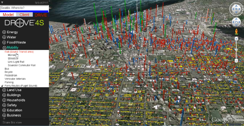
Drive’s interface gives an idea of the platform’s versatility, depth and simplicity. It looks like a game, something like SimCity, but with real-life images and data. In one view, the user can survey all dwellings, color-coded in three dimensions. “Yellow is single family, multiplexes are orange, apartments are red, condominiums are blue, under construction is in white and hotels are green,” Borrero explained.

The user can also generate heat maps for a desired metric, such as mobility/transportation (pictured above).

The context lent by Drive's interface goes beyond what’s possible through two-dimensional maps and documents viewed out of context, Borrero said. If a user is interested in viewing where a given ethnicity of people live, like Asians (pictured above), that information is available in rich detail. Crucial details are often lost when viewing data through traditional means, because they are not obvious. A region that is 100 percent Asian but has only two inhabitants contains a far different value proposition than a region that is 100 percent Asian and has 300 inhabitants. Drive ensures those kinds of understandings are clear to the user, said Borrero.

Drive also allows the user to track ongoing initiatives and information associated with map data. The platform isn’t just a map, Borrero said, but a hub for all the information associated with a place. The platform links to data published on the city’s website, allowing the user to use Drive as a central tool for planning, he said.

The user can also view land parcels prone for redevelopment (pictured above). This functionality has been made publicly available in several municipalities around the nation through the deployment of dedicated tools, but a centralized tool like Drive allows the user to make more meaningful analyses of the data by comparing it with other layers and examining information across agencies.
Borrero is an architect by trade, and when he first began speaking with public officials to develop urban best practices in sustainability in 2007, he said he realized department heads often did not understand one another.

“It made me realize the biggest impediment in sustainable development is the lack of clarity, the lack of understanding of the parts,” he said. “You need a visual platform so people understand the way the systems impact your city and property around you.”
Before Borrero started pitching his software to real estate developers in 2012, he tried to get the city of Seattle to use an early version of Drive, but officials passed. The city already had GIS, according to Borrero, and there was no line-item permitting the use of a new platform. City lawyers were also worried about their relationship with existing vendors like Esri and Microsoft, he said.
Building the system for another municipal region similar to Greater Seattle, would cost about $500,000, Borrero said. "Using the tool today costs $5k/year per user with a minimum of 5 licenses. Larger discounts are available for larger groups," he explained.
Today, the city provides Drive with data, but isn't using the platform. Borrero said the reason stems from a lack of urgency and failure to collaborate efficiently.
“The public sector really has no urgency to think differently, no urgency to innovate,” he said. “They have an urgency to check boxes, unfortunately. This is something that creates value for everyone, every department, so that means that no department will pay for it itself.”
Another barrier to adoption, Borrero said, is that when he pitches Drive to governments, he meets with GIS staff because his product is viewed as a technical tool. GIS staff are a link between the data and the decision-makers who don’t know how to use the software. But Drive allows decision makers to directly access the information in a way they can easily understand and manipulate, without the need for assistance from technical staff.

DriveDecision can also help break down information silos between local governments, facilitating the development of today's smart city trend, Borrero said. The San Francisco Bay Area, for instance, contains more than 100 municipalities, each with their own siloed data sets. Before cities can get smart, they need to collaborate regionally, Borrero said, and to do that, they need an intuitive platform that goes beyond the capabilities of the software they use today.
That’s why McGinn’s role will be to explain to cities how they can collaborate and share their data to help everyone in government make better decisions. Borrero wants King County, Wash., to make its tool a component of the county’s long-term development plans.
“I think Mike is a great person to be out there talking about integration of municipalities as the next phase of sustainable cities, and it’s not really cities, it’s municipal regions,” Borrero said.
Though Borrero has experienced the lethargy of government first-hand, he said he’s confident that once citizens and the private sector begin adopting technology like Drive more regularly and proving what’s possible, the public sector is sure to catch on.
Editor's note: This story was edited at 3 p.m. on Dec. 11 to correct minor factual errors.