In this month’s installment of the Innovation of the Month series, we explore the University of Miami’s Land Access for Neighborhood Development tool, a mapping platform that visualizes the distribution of Miami’s underused properties to help identify potential development opportunities for affordable housing.
MetroLab’s Ben Levine and Stefania Di Mauro-Nava spoke with Robin Bachin, assistant provost for Civic and Community Engagement, and Jorge Damian de la Paz, senior program manager, both in the UM Office of Civic and Community Engagement; Michael Liu, director of the Miami-Dade County Public Housing and Community Development Department; and Annie Lord, executive director of Miami Homes for All, to learn more.
Stefania Di Mauro-Nava: Could you please describe what the Land Access for Neighborhood Development (LAND) is? Who is involved in this effort?
Robin Bachin: The LAND mapping platform visualizes the distribution of Miami’s underused properties owned by a municipality, anchor institution or faith-based organization. Developed by the University of Miami (UM)’s Office of Civic and Community Engagement (CCE), in collaboration with the UM Center for Computational Science, and with support from Citi Community Development, LAND enables policymakers and community-based organizations to identify potential development opportunities for affordable housing in transit-served areas in order to promote equitable and inclusive community development. LAND is one of several projects housed under CCE's Miami Housing Solutions Lab.
During the course of LAND’s two-year development, CCE engaged numerous community groups — from the Florida Housing Coalition to Catalyst Miami — to solicit feedback and ensure the final version of LAND effectively meets local stakeholder needs. CCE also collaborated with the city of Miami’s housing department to incorporate the city’s vacant uncommitted properties onto LAND, allowing for the inclusion of a data set that had previously never been mapped on an interactive platform. In March 2019, we launched LAND in partnership with various key stakeholders, including the Federal Reserve Bank of Atlanta, Miami Mayor Francis Suarez, and the Miami-Dade County Department of Public Housing and Community Development, among others. These meaningful community partnerships provided CCE with critical input on the platform and have allowed LAND to achieve product-market fit.

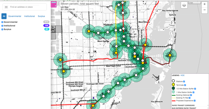
LAND allows users to easily visualize concentrations of surplus vacant county properties, shown in purple, and city of Miami-owned uncommitted properties, represented in teal. University of Miami’s Office of Civic and Community Engagement (2018).
Ben Levine: Can you describe what particular challenges this tool addresses?
Jorge Damian de la Paz: The LAND mapping platform represents, for the first time, a mechanism for seeing the total amount of public- and institution-owned, underutilized, or vacant land across Miami-Dade County, including where the lots are located, who owns them and how they could be aggregated into larger parcels. By gathering scattered property and transit information into one place for the very first time, LAND is solving a real data pain point for community groups. Furthermore, by making LAND free and publicly accessible, CCE is helping to democratize information that was previously only available to the few people or organizations with the resources to track it down. Through LAND, this property data is now more transparent and accessible to everyone.
Metro Miami has the highest combined housing and transportation costs in the country, according to the Center for Neighborhood Technology. To create more sustainable neighborhoods and facilitate much-needed affordable housing near rapid transit, LAND allows users to easily identify vacant municipal and institution-owned lots within walking distance of a transit station. Policymakers, planners, and community groups can now use LAND to craft more comprehensive and data-driven land use strategies in transit-served areas.
Michael Liu: CCE’s simple-to-use tool allows the county to easily visualize the landscape of underused properties for the very first time. Their rich LAND data will augment a recently released county report of possible land available for affordable and workforce housing units in transit corridors. We have worked with UM CCE to provide demos on their various tools, including LAND, to enhance our evidence-based decision-making and planning.
Levine: What have been some of your initial findings, and how have these findings impacted the current and future work of LAND?
Bachin: From parking lots to vacant plots, LAND has identified almost 500 million square feet of potentially underused land owned by a municipality, large anchor institution or faith-based organization(s). However, some of these properties could be suboptimal or unbuildable because of environmental contamination, encumbrances, lot shape or zoning. As a result, we intend to continuously update and refine this data set to better identify how these properties could be best used to create affordable housing, parks or land conservation areas to address flooding and help alleviate storm surge.

Users can overlay County or City Commission Districts. University of Miami’s Office of Civic and Community Engagement (2018).
Di Mauro-Nava: How are some of the initial findings being used and implemented by the city and/or community?
de la Paz: Miami-Dade County’s Department of Public Housing and Community Development has contracted CCE to provide its staff with demonstrations of LAND to encourage more strategic affordable housing and land use policies across the county. In October, the Center for Community Progress, a national nonprofit focused on property revitalization, presented to the Board of County Commissioners potential land use strategies that could transform the vacant lots shown on LAND into community assets. The city of Miami’s housing agency and planning department have also used LAND to explore potential cross-locality partnerships to build more affordable housing.
Bachin: After the release of LAND, more than 20 community groups formed a new coalition to ensure that local authorities used their vacant properties in ways that are sustainable, inclusive and beneficial to the public. This group drafted a joint-values statement, “Public Land for Public Good,” which outlines various goals for the county, municipalities and school board to consider when developing, selling, or donating local government-owned land. These core values emphasized incorporating residents in the decision-making process, promoting resiliency and environmental sustainability, and cross-locality coordination.
Annie Lord: Miami Homes for All is guiding various cross-sector efforts to address Miami’s housing crisis, some of which have been informed by data from CCE’s LAND tool. In May 2019, we released our Connect Capital Miami Report with the city of Miami, which includes proposals to generate 12,000 affordable homes by 2024. Among the report’s proposals was to identify adjacent parcels of publicly owned vacant and underused land using the LAND tool and assemble them for affordable housing. Along with the “Public Land for Public Good” coalition, we are now convening leaders from across sectors to craft a public land strategy and maximize the use of public land for affordable housing. We are committed to ensuring that vacant and underused government-owned properties highlighted on LAND are used in ways that benefit Miami’s lowest-income residents.
Di Mauro-Nava: What was the most surprising thing you learned during this process?
Bachin: Through LAND’s filters and search features, users have the ability to distinguish vacant, available city or “surplus” county lots from non-surplus municipal lots. Using LAND, CCE has found multiple examples of potentially available surplus lots alongside vacant local government-owned lots, which if assembled together could form a viable development opportunity for affordable housing. This is an insight that would not be immediately apparent if you were just looking at a list or spreadsheet of available municipal-owned lots.
Levine: Where will this project go from here?
de la Paz: Because it's a Web-based tool, we can continue to build, refine and improve on LAND in a way that is not possible with a standard planning or policy report. Through regular data updates, LAND is able to capture the latest market and policy changes in almost real time. Furthermore, we hope to eventually incorporate new layers to the tool like zoning, water/sewer connection or encumbrances to provide even greater insights and promote more inclusive community development in Miami.
Liu: My department recently compiled for public dissemination a list of projects that we hope will account for 14,025 new affordable and workforce housing units that will have at a minimum gone through financial closing by the end of November 2020. LAND will be able to help us monitor the progress of these projects as well as spatially determine if there are other opportunities in areas within near proximity of these projects that we've not yet recognized or contemplated.
We have also recently spearheaded new collaborations with the school board and library system to build hundreds of affordable units on public land not traditionally used for housing. We have also set aside $2 million of our Surtax program for “innovative” affordable housing projects to spur local experimentation with new building materials, accessory dwelling units and community land trusts. This resource could also be used for new affordable housing developments that incorporate land owned by educational organizations or religious institutions. LAND’s ability to search and filter vacant properties could help to further encourage these types of cutting-edge housing solutions.
Lord: The LAND tool can play an instrumental role in developing the affordable housing we desperately need right now. Miami Homes for All looks forward to working with local and national partners to advance policy solutions and innovative ownership models that will transform these vacant properties into vibrant communities so that all Miamians have safe and stable homes.


